- Where the Climate Prediction Center heavy snow map shows the greatest risk
- NOAA forecasts one of the warmest Novembers across the United States
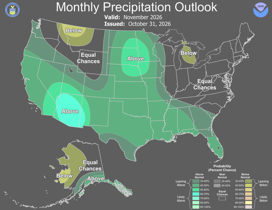
- Which states could see more rain and snow in November?
- How December forecasts from NOAA and private forecasters compare
- Could an early polar vortex disruption change the winter outlook?
The Climate Prediction Center heavy snow map shows a moderate risk of significant snowfall across mountainous areas of California and southern Oregon from November 13 through November 15, even as unusually warm temperatures are expected across most of the United States during November.
The National Oceanic and Atmospheric Administration’s (NOAA) Climate Prediction Center issued the warning in its week-two hazards outlook. The affected areas include major mountain highways where winter driving restrictions could become necessary despite relatively mild conditions at lower elevations.
- NOAA’s Climate Prediction Center identifies a moderate risk of heavy snow in California’s Sierra Nevada and Klamath Mountains and the mountains of southern Oregon from November 13 to 15.
- Most of the US is expected to experience above-average temperatures in November, while a separate December outlook favors cooler conditions in southern California, Arizona and southwestern New Mexico.
- A possible early polar vortex disruption could influence late November and December weather, although forecasters remain uncertain about its effects on surface temperatures.
The outlook comes amid a developing weather pattern dominated by a strong El Niño, which is expected to contribute to one of the warmest Novembers on record nationally. Longer-range forecasts suggest that much of the country could remain warmer than average into December, although parts of the Southwest may experience colder conditions.
A possible disruption of the polar vortex adds uncertainty to the outlook for late November and December.
Where the Climate Prediction Center heavy snow map shows the greatest risk
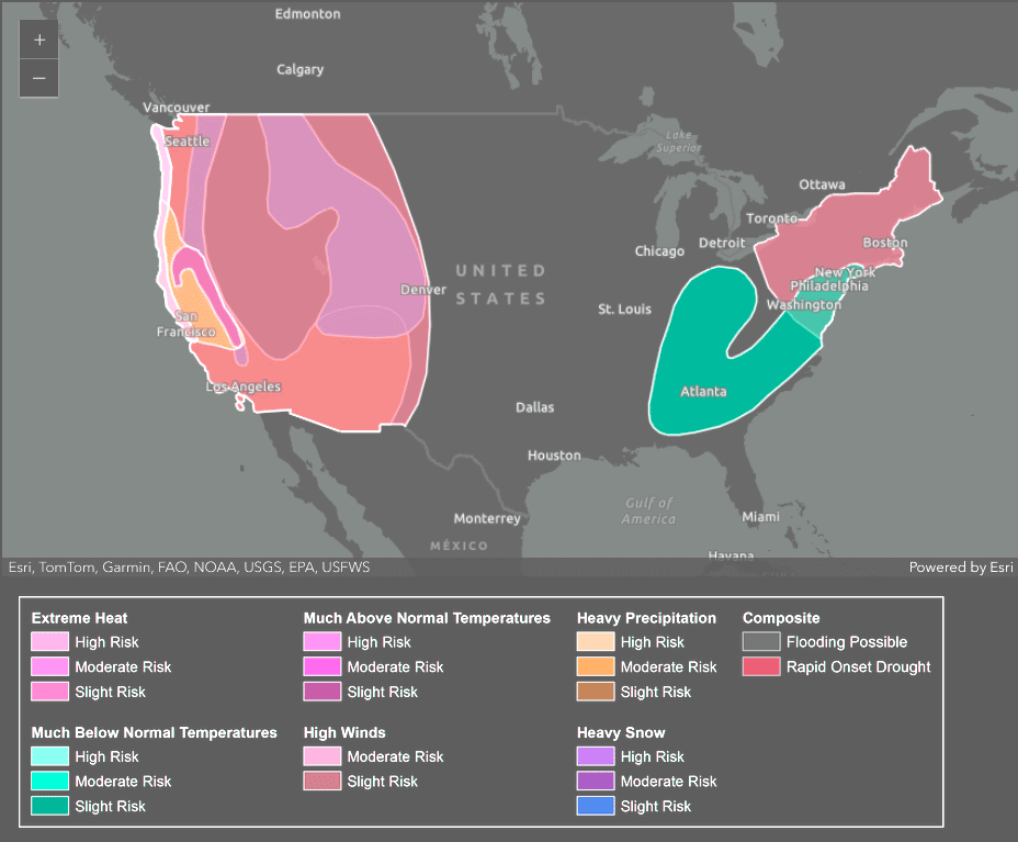
The CPC hazards map, released November 5, identifies two states under a moderate risk of heavy snow between November 13 and 15.
In California, the designated area covers the Sierra Nevada and Klamath Mountains. The risk extends north into the mountains of southern Oregon, including the Klamath range.
The map marks heavy snow areas in pink, while green shading identifies regions at risk of heavy precipitation. The precipitation zone extends beyond the main snow area into Washington, Oregon and California.
Snow levels are expected to remain relatively high, meaning much of the precipitation at lower elevations should fall as rain.
All three West Coast states also face a moderate risk of high winds along coastal areas during November 13-15.
The geographical coverage of potential winter weather is broader than the map’s principal snow warning. In its accompanying outlook, the CPC identifies a slight risk of heavy snowfall at higher elevations through November 17 across the Cascades, portions of the northern Intermountain West and Great Basin, and the Central and Northern Rockies.
A slight risk of high winds also extends across much of the West Coast and Interior West through November 17.
CPC forecaster Thomas Collow reported that the probability of three-day snowfall accumulations exceeding six inches had decreased compared with the November 4 outlook.
The reduction indicates that the forecast remains subject to revision, particularly regarding snowfall intensity and the geographical extent of the affected mountain areas.
Sierra Nevada highways face possible chain restrictions
The forecast snow zone includes major transportation corridors through California’s Sierra Nevada, particularly Interstate 80 at Donner Summit and U.S. Route 50 at Echo Summit.
Drivers traveling through these mountain passes between November 13 and 15 could encounter chain controls near higher elevations, even if roads remain wet rather than snow-covered farther downhill.
California operates three levels of tire-chain restrictions, depending on road and weather conditions.
Under R2 restrictions, which are commonly imposed in the Sierra Nevada, vehicles equipped with four-wheel or all-wheel drive and snow tires on all four wheels are generally exempt from installing chains. Drivers must still carry chains.
At the more restrictive R3 level, chains are required on every vehicle, regardless of its drivetrain. These restrictions become particularly relevant when snow levels are elevated because conditions can change considerably over relatively short distances on mountain highways.
High winds present a separate hazard for West Coast motorists. SUVs, pickup trucks, vans and vehicles towing trailers can be particularly vulnerable to strong crosswinds on exposed roads and bridges.
Motorists planning to cross the Sierra Nevada or southern Oregon mountains during the affected weekend should carry chains, maintain adequate fuel supplies and check current road conditions before departure.
California’s Caltrans QuickMap and Oregon’s ODOT TripCheck provide updated information about road restrictions, closures and driving conditions.
NOAA forecasts one of the warmest Novembers across the United States
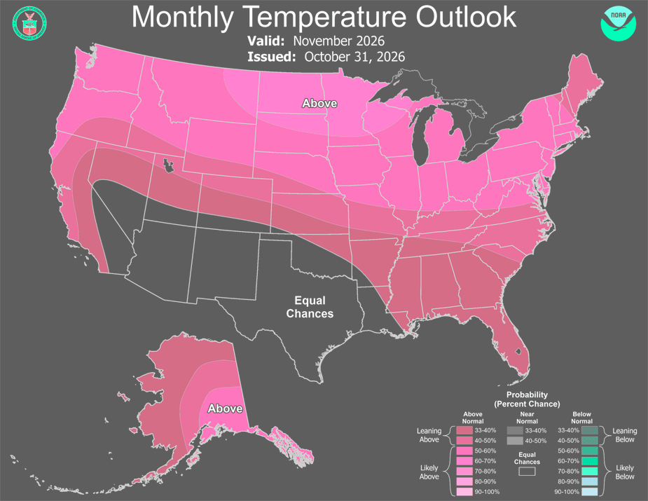
Despite the approaching mountain snow risk, the broader national temperature outlook remains unusually warm.
NOAA’s Climate Prediction Center expects above-average temperatures across nearly the entire contiguous United States during November 2026.
The monthly temperature outlook places most of the country in categories favoring warmer-than-normal conditions, with the Southwest representing the principal exception.
In that region, NOAA assigns equal chances to above-normal, near-normal and below-normal temperatures rather than identifying a dominant outcome.
Johnna Infanti, a forecaster at NOAA’s Climate Prediction Center, attributed much of the expected warmth to the ongoing El Niño. “The ongoing El Niño remains the dominant teleconnection to influence this forecast (for November),” Infanti wrote in the center’s monthly outlook discussion.
Merrill also pointed to unusually warm Pacific Ocean waters and an energized Pacific jet stream as major influences on the national temperature pattern.
A highly energized Pacific jet stream triggered by both the strong El Niño and marine heat waves in the Pacific are flooding much of the U.S. with warmer-than-average temperatures in November.
Johnna Infanti, a forecaster at NOAA’s Climate Prediction Center
El Niño develops when tropical Pacific Ocean temperatures become unusually warm, affecting atmospheric circulation and the position of the jet stream.
In the United States, the resulting winter pattern frequently favors milder conditions across northern states while increasing precipitation potential farther south.
Which states could see more rain and snow in November?
NOAA’s precipitation outlook identifies the Southwest and the central and northern Plains as areas with elevated probabilities of above-average precipitation during November.
The forecast also indicates that Michigan and Montana are the only states favored to experience below-average precipitation for the month.
The anticipated combination of mild temperatures and an active Pacific storm track means precipitation type will depend heavily on elevation and the timing of individual weather systems.
AccuWeather expects at least one substantial storm to affect the western United States during November.
AccuWeather expects elevated coastal water levels to continue during November, with some of the highest levels of the season potentially occurring around November 25.
Farther east, the forecaster anticipates another storm closer to Thanksgiving week, bringing heavy rain to parts of the Southeast and Mid-Atlantic.
A colder air mass could arrive around Thanksgiving weekend, potentially producing flurries or snow in portions of the Great Lakes and Northeast.
Near-freezing overnight temperatures are also possible in parts of the Middle Mississippi Valley, Ohio Valley and Mid-Atlantic.
For many locations in those regions, such temperatures could represent the season’s first freeze, arriving approximately two to three weeks later than usual.
How December forecasts from NOAA and private forecasters compare
Several forecasting organizations expect an unusually mild start to winter across northern parts of the United States, although their assessments differ regarding the extent and duration of colder weather in southern regions.
AccuWeather’s winter forecast anticipates below-average temperatures across portions of the central Rockies, Southwest and Gulf Coast over the December-February period.
The company identifies Phoenix and Las Vegas among cities where colder conditions could increase heating demand. Its outlook nevertheless favors a warm beginning to December across the Upper Midwest and Great Lakes.
NOAA’s official seasonal forecast is less definitive about the likelihood of colder conditions. In its October 15 seasonal outlook, the Climate Prediction Center assigned equal chances of above-normal, near-normal and below-normal temperatures to much of the Southwest.
The federal outlook did not identify any part of the contiguous United States where below-normal temperatures were the favored outcome for the full season. These projections cover different periods, an important distinction when comparing their results.
The Weather Company’s December outlook addresses a single month, while the AccuWeather and NOAA seasonal assessments cover December through February. A region can experience a colder-than-average December without necessarily recording below-normal temperatures across the entire winter.
What El Niño could mean for a white Christmas
The developing El Niño pattern may also influence the geographical distribution of snow cover on Christmas morning.
The Weather Company examined historical white Christmas probabilities associated with the six strongest El Niño events since 1950.
That comparison suggests substantially lower-than-usual chances of snow on the ground across areas extending from the Great Lakes into the Northeast.
The historical relationship does not constitute a specific snowfall or snow-cover forecast for December 25, 2026.
Conditions in individual locations will still depend on temperatures, storm tracks and snowfall during the weeks preceding Christmas.
The historical analysis identifies a different tendency across the higher elevations of the southern Rockies.
Parts of Arizona, Colorado, New Mexico and Utah show better-than-usual odds of having snow on the ground on Christmas morning during comparable strong El Niño periods.
The contrast reflects the different regional weather patterns that can develop during strong El Niño winters, with relatively mild northern conditions occurring alongside more favorable snowfall conditions in parts of the southern mountains.
Could an early polar vortex disruption change the winter outlook?
An unusually early disturbance of the stratospheric polar vortex introduces another source of uncertainty into the late-autumn and early-winter forecast.
The polar vortex is a large circulation of strong winds high above the Arctic. Under certain atmospheric conditions, rapid warming in the stratosphere can weaken or disrupt that circulation.
Such events can influence weather patterns at lower altitudes, although their effects are neither immediate nor geographically uniform.
In its updated November outlook, NOAA’s Climate Prediction Center described sudden stratospheric warming events during November as very rare. The center noted that their atmospheric effects can persist for as long as two months. Forecast guidance indicates the possibility of a brief reversal of stratospheric winds during the second week of November.
According to The Watchers, the projected reversal would occur more than two weeks earlier than the November events documented in NOAA’s historical compilation of sudden stratospheric warmings.
Changes in stratospheric circulation generally take weeks to influence surface weather, making late November and December the relevant periods for monitoring any potential consequences.
A disruption does not automatically lead to widespread cold weather across the United States.
NOAA notes that the possible stratospheric signal is competing with the influence of El Niño, which remains a major factor in the current seasonal forecast.
The timing, strength and geographical distribution of any resulting temperature changes therefore remain uncertain.
What the latest forecasts mean for November travel
The immediate weather concern remains concentrated in the western mountains, where the Climate Prediction Center identifies a moderate risk of heavy snow. The forecast does not indicate that widespread winter conditions are imminent across the country.
Much of the contiguous United States is expected to remain warmer than average during November, with precipitation and mountain snowfall presenting more immediate hazards in western regions.
Drivers crossing the Sierra Nevada or southern Oregon should monitor updated forecasts because the probability of substantial snowfall has already declined from the previous CPC outlook.
Chain restrictions, mountain road closures and reduced visibility could still affect travel where heavy snow develops.
Farther east, the possibility of the season’s first freezing nights warrants attention even where daytime temperatures remain relatively mild.
Tire pressure typically falls by approximately 1 psi for every 10-degree Fahrenheit decline in temperature, making morning pressure checks relevant as overnight temperatures approach freezing.
Beyond the November 13-15 mountain snow risk, forecasters will be monitoring the interaction between El Niño, Pacific storm activity and the possible early polar vortex disturbance to assess whether the prevailing warm pattern persists into December.