Climatic conditions this year suggest that there will likely be slightly fewer hurricanes in the North Atlantic than the long-term average. On the other hand, these conditions are conducive to the formation of typhoons in the Northwest Pacific, which are more likely to hit Japan, the Greater China region or Korea.
Munich Re expects the 2026 North Atlantic hurricane season to be slightly less active than the long-term average, while conditions in the Pacific could produce more typhoons and increase the risk of landfall in Japan, Greater China and Korea.
The contrasting forecasts are largely driven by the El Niño/Southern Oscillation (ENSO), a natural climate pattern that influences tropical cyclone formation and extreme weather across multiple regions.
An El Niño phase was forecast to develop during the summer of 2026, bringing unusually warm sea surface temperatures to the central and eastern equatorial Pacific. The phenomenon could intensify into a relatively rare “Super El Niño” by the end of the year, when sea surface temperature anomalies exceed 2°C and the potential for widespread atmospheric effects increases.
Key highlights
- Munich Re forecasts 12-13 named storms in the North Atlantic in 2026, including five or six hurricanes and potentially two major hurricanes, below the 30-year average.
- A developing El Niño, potentially strengthening into a Super El Niño by year-end, is expected to suppress Atlantic hurricane activity while favouring tropical cyclone formation in the Pacific.
- Northwest Pacific activity could reach 27 named storms, including 18 typhoons and 11 severe typhoons, increasing the potential threat to Japan, Greater China and Korea.
El Niño generally suppresses hurricane formation in the tropical North Atlantic but favours cyclone development in the Northeast Pacific, off the western coasts of the US and Mexico. Similar conditions tend to increase typhoon activity in the Northwest Pacific.
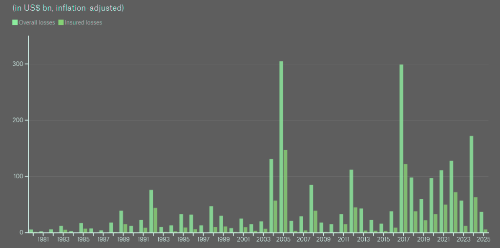
Global losses from tropical cyclones 1980-2025
These regional differences have important implications for catastrophe exposure, particularly as tropical cyclones remain among the costliest natural disasters for insurers and reinsurers.
Unlike in previous years, the outlook for this cyclone season is relatively clear: given the El Niño conditions, we can expect to see a slightly weaker hurricane season and a stronger typhoon season. However, even in quieter seasons, there can always be very serious events that are impossible to predict.
Anja Rädler, Meteorologist and climate expert at Munich Re
“In order to minimise losses, the focus must be on prevention. As history has shown, even a single storm can produce massive losses”.
Global tropical cyclone economic and insured losses, 1980-2025
| Region | Economic losses | Insured losses |
|---|---|---|
| North America and Caribbean | $1.8 tn | $800 bn |
| Global total | $2.4 tn | $900 bn |
| North America and Caribbean share | 75% | 90% |
| Asia and Australia/Oceania share | 24% | 11% |
Figures are inflation-adjusted. Regional shares are rounded.
North Atlantic hurricane season forecast for 2026

Munich Re’s assessment of climatological conditions points to a moderately below-average Atlantic hurricane season in 2026.
Based on the combined estimates of leading research institutes, approximately 12-13 named tropical cyclones are expected to form in the North Atlantic. Five or six could strengthen into hurricanes, including potentially two major hurricanes with sustained winds exceeding 110 mph (177 km/h).
Forecasts differ considerably between individual research institutes, reflecting the uncertainty involved in predicting seasonal storm activity.
The projected numbers are slightly below the 30-year average of 15.6 named storms, 7.6 hurricanes and 3.5 major hurricanes. That historical period has been characterised by a warm phase of Atlantic Multidecadal Variability (AMV), associated with elevated sea surface temperatures and increased tropical cyclone activity in the North Atlantic.
2026 hurricane and typhoon season forecast
| Tropical cyclone basin | 2026 forecast | 30-year average |
|---|---|---|
| North Atlantic named storms | 12-13 | 15.6 |
| North Atlantic hurricanes | 5-6 | 7.6 |
| Major Atlantic hurricanes | 2 | 3.5 |
| Northwest Pacific named storms | 27 | 24.5 |
| Northwest Pacific typhoons | 18 | 15 |
| Severe Pacific typhoons | 11 | 8.7* |
Alongside ENSO, tropical Atlantic sea surface temperatures are a primary influence on hurricane formation.
At the time, waters in the tropical North Atlantic and Gulf of Mexico were warmer than average. These conditions could support above-normal storm activity early in the hurricane season, before the anticipated El Niño fully develops.
El Niño also affects hurricane trajectories. Storms tend to turn northward earlier under these conditions, potentially reducing the number entering the Caribbean Sea and Gulf of Mexico while increasing the likelihood of landfall along the southern portion of the US East Coast.
Seasonal forecasts provide limited guidance on where individual storms will strike or how destructive they may become. A relatively quiet season can still generate substantial economic and insured losses if a powerful hurricane reaches a densely populated coastal area.
Hurricane Andrew demonstrated that risk in 1992, when it devastated parts of Florida during an El Niño event and prompted insurers to reassess their understanding of severe hurricane exposure.
Andrew remains among the ten costliest hurricanes in US history. Its inflation-adjusted economic losses total approximately $64 bn, with insurers covering nearly two-thirds.
A comparable hurricane striking the same area today would generate substantially higher losses because the value of exposed property has increased considerably.
El Niño increases hurricane activity in the Northeast Pacific
Conditions in the Northeast Pacific generally develop differently from those in the Atlantic during El Niño years.
Warmer waters and associated atmospheric changes favour tropical cyclone formation off the western coasts of Mexico and the US, potentially producing a more active hurricane season.
The destructive potential of these storms was evident in 2023, when Hurricane Otis rapidly intensified before devastating Acapulco, a major tourist destination on Mexico’s Pacific coast.
Otis caused approximately $14 bn in inflation-adjusted economic losses, including nearly $5 bn in insured losses.
El Niño impact on hurricane and typhoon risks in 2026
| Region | Expected impact | Areas at risk |
|---|---|---|
| North Atlantic | Below-average hurricane activity | US East Coast, Caribbean |
| Northeast Pacific | Increased hurricane formation | Mexico’s Pacific coast |
| Northwest Pacific | Above-average typhoon activity | Japan, Greater China, Korea |
| Caribbean and Gulf of Mexico | Fewer storms potentially entering the region | Caribbean islands, Gulf Coast |
The storm illustrated how severe Pacific hurricanes can produce considerable damage when they strike heavily developed coastal communities, even though Atlantic hurricanes account for a much larger share of historical insured catastrophe losses.
Northwest Pacific typhoon activity could exceed 30-year average
Munich Re expects above-average tropical cyclone activity in the Northwest Pacific during 2026, with El Niño conditions favouring both storm development and tracks that could expose Japan, eastern China and Korea to greater risk.
An initial forecast from Tropical Storm Risk (TSR) projects 27 named storms, including 18 typhoons and 11 severe typhoons. These estimates exceed the region’s 30-year averages of 24.5 named storms, 15 typhoons and 8.7 super typhoons.
ENSO affects both the frequency of Northwest Pacific tropical cyclones and the locations where they develop and travel.
During El Niño phases, typhoon tracks tend to shift northeastward, increasing the likelihood of storms approaching eastern China, the Korean Peninsula and Japan.
Under neutral or La Niña conditions, tropical cyclones are more likely to affect southern China, the Philippines and Vietnam.
Longer-term climate projections add another consideration. Scientists expect climate change to contribute to a poleward shift in typhoon tracks, potentially increasing exposure around the East China Sea and Japan over time.
The combination of seasonal El Niño conditions and longer-term changes in storm trajectories points to significantly elevated typhoon risk for Greater China, Korea and Japan in 2026.
The potential consequences are illustrated by previous major storms, including Super Typhoon Mangkhut, which caused extensive damage in Hong Kong in 2018.
Tropical cyclone losses and implications for insurers
Tropical cyclones are classified under different regional names. They are known as hurricanes in the North Atlantic and Northeast Pacific, typhoons in the Northwest Pacific, and cyclones in the Indian Ocean and South Pacific. Their financial consequences vary substantially between regions, particularly in terms of insurance coverage.
According to Munich Re’s historical catastrophe data, tropical cyclones in North America and the Caribbean have accounted for approximately three-quarters of global inflation-adjusted economic losses from these events since 1980.
Total worldwide economic losses reached approximately $2.4 tn, of which around $1.8 tn originated in North America and the Caribbean.
The concentration is even greater for insured losses. Storms affecting these regions generated approximately $800 bn of the global insured total of just under $900 bn, representing around 90%.
Asia and Australia/Oceania accounted for approximately 24% of total economic losses but only about 11% of insured losses over the 1980-2025 period.
Costliest historical examples referenced in the 2026 outlook
| Hurricane | Year | Economic losses | Insured losses |
|---|---|---|---|
| Hurricane Andrew, US | 1992 | $64 bn | Nearly two-thirds of total |
| Hurricane Otis, Mexico | 2023 | $14 bn | Nearly $5 bn |
The figures demonstrate the substantial geographical differences in insurance coverage for tropical cyclone damage, with North America and the Caribbean accounting for a disproportionately large share of insured catastrophe costs.
Global losses from tropical cyclones were relatively limited in 2025, largely because no storms made landfall on the US mainland, despite several developing into extremely powerful systems.
For insurers and reinsurers, this illustrates why seasonal storm counts alone cannot reliably predict annual catastrophe losses. Landfall location, storm intensity and the value of exposed assets remain central determinants of economic damage and insurance claims.
The Atlantic hurricane season officially runs from June 1 through November 30. Storms occasionally develop outside those dates, although the probability is considerably lower.
Typhoons in the Northwest Pacific can occur later, including during January and February, particularly over the consistently warm waters in the southern part of the basin near the Philippines.
Munich Re’s 2026 outlook therefore points to different regional risk profiles: somewhat lower expected hurricane activity in the North Atlantic, alongside greater potential for typhoon activity and landfall exposure in parts of East Asia.
………………
EXPERTS: Anja Rädler – Meteorologist and climate expert at Munich Re, Andreas Lang – Climate Scientist at Munich Re
Edited by Yana Keller – Re/Insurance Editor at Beinsure