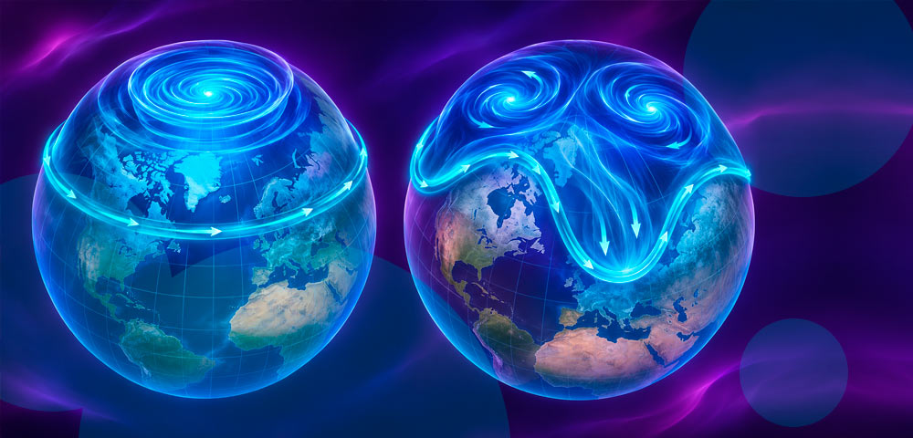
An unusually early disruption of the Arctic polar vortex could increase the risk of colder weather and snowfall across the UK later in November and December, although meteorologists say its effects remain uncertain.
Powerful winds circulating high above the North Pole have weakened significantly, causing the polar vortex to stretch and temporarily divide into two separate circulations.
- The Arctic stratospheric polar vortex has weakened and temporarily split, with forecasts indicating a possible reversal of its winds by mid-November 2026.
- A major sudden stratospheric warming (SSW) event could become the earliest recorded, potentially increasing the likelihood of colder weather and snow across parts of the UK and Europe.
- The Met Office cautions that a polar vortex disruption does not guarantee severe winter conditions, while experts recommend preparing for possible cold spells and weather-related disruption.
Some forecast models indicate that the prevailing westerly winds could reverse direction by mid-November, potentially producing a major sudden stratospheric warming (SSW) event. If confirmed, the reversal could be the earliest such event in modern observational records.
The Met Office says changes in the stratosphere can eventually influence the jet stream and increase the likelihood of cold northerly or easterly winds reaching Britain.
However, the disruption does not establish that the UK will experience widespread snow or prolonged freezing temperatures.
What is happening to the polar vortex in November 2026?
The stratospheric polar vortex is a circulation of strong westerly winds that develops over the Arctic as temperatures fall during autumn.
The winds operate approximately 10-30 miles (15-50 kilometers) above Earth’s surface and typically strengthen through December and January.
This circulation influences atmospheric patterns across the Northern Hemisphere.
Disturbances originating lower in the atmosphere can travel upward and weaken the vortex. Under certain conditions, rapid warming in the stratosphere can cause the prevailing winds to reverse from westerly to easterly. This reversal is a defining feature of a major sudden stratospheric warming event.
Meteorologists have observed substantial weakening and displacement of the polar vortex during early November 2026. The circulation has also stretched and briefly split into two smaller systems.
Forecast models suggest that a major SSW could develop by mid-November, several weeks earlier than such events typically occur.
Previous major SSW events have occurred as early as November 28, including events associated with 1968-69 and 2025.
Could the polar vortex bring snow to the UK?
A disrupted polar vortex can alter atmospheric circulation and weaken or displace the jet stream. This may encourage persistent high-pressure systems that block the normal movement of Atlantic weather systems.
Depending on their location, these blocking patterns can allow colder Arctic or continental air to move towards the UK. Northerly winds can bring colder Arctic conditions, while easterly winds may transport cold air from mainland Europe.
Both patterns can increase the possibility of frost, ice and snowfall when sufficient moisture is available.
Eastern parts of the UK can be particularly exposed to wintry showers during sustained easterly flows.
However, an SSW does not automatically produce colder weather at the surface. The effects depend on how changes in the stratosphere interact with weather patterns closer to the ground. A substantial disruption could influence weather patterns for approximately 30-40 days.
Could Britain experience another Beast from the East?
The potential disruption has prompted comparisons with the severe winter weather associated with the Beast from the East in 2018. That event followed a sudden stratospheric warming and brought exceptionally cold continental air across the UK.
The resulting conditions included widespread snowfall and prolonged freezing temperatures.
A comparable outcome is not currently assured because much of Europe has yet to experience the intense cold necessary to produce a similar event.
Other European countries could experience more significant effects depending on where atmospheric blocking develops.
British Weather Services identified Norway, Sweden, Denmark and Germany among the areas currently considered possible locations for the strongest effects.
The Met Office has also noted that a major SSW in November 2025 did not produce substantial cold weather across the UK.
How El Niño could affect the UK winter forecast
The unusually early polar vortex disruption is occurring alongside a strong El Niño event in the tropical Pacific Ocean.
El Niño influences atmospheric circulation by changing sea surface temperatures and weather patterns across the Pacific. These changes can strengthen planetary waves that travel from the lower atmosphere into the stratosphere.
The waves can disturb the polar vortex, causing it to weaken, shift position or split.
Met Office explained that El Niño can increase the probability of sudden stratospheric warming events through this process. However, scientists have not established that El Niño caused the current disruption.
The University of Reading has also cautioned that further analysis is required to determine the relationship between the unusually strong El Niño and the early weakening of the vortex.
Before the disruption became apparent, longer-range forecasts generally favored a wetter and stormier beginning to winter, followed by a greater possibility of colder conditions in early 2027.
The potential SSW introduces additional uncertainty into that outlook.
When could colder weather reach Britain?
Changes in the stratosphere typically take time to influence weather near Earth’s surface. If a major SSW develops in mid-November, any resulting changes in UK temperatures and precipitation could emerge during the following weeks.
Late November and December are therefore periods meteorologists will monitor for potential changes in circulation patterns. The timing and severity of any cold spell remain uncertain.
The Met Office has emphasized that there is less widespread cold air available across the Northern Hemisphere in early November than during the middle of winter. That could limit the immediate consequences of an unusually early disruption.
The location of blocking high-pressure systems will also determine whether the UK experiences colder conditions or whether the strongest effects develop elsewhere in Europe.
UK winter preparation as polar vortex disruption develops
Meteorologists recommend that households remain prepared for the possibility of winter weather disruption without assuming that a severe cold spell is inevitable.They encouraged people to consider their ability to manage extreme weather, including situations involving interruptions to electricity, water or gas supplies.
Practical preparations can include checking household heating arrangements, maintaining essential supplies and monitoring official weather warnings.
The Met Office continues monitoring the polar vortex, the possibility of a major sudden stratospheric warming event and whether changes in upper-atmosphere circulation begin influencing UK weather.
The next significant development will be whether the weakening westerly winds reverse direction, confirming a major SSW and providing forecasters with additional information about possible winter conditions.