Follow Beinsure
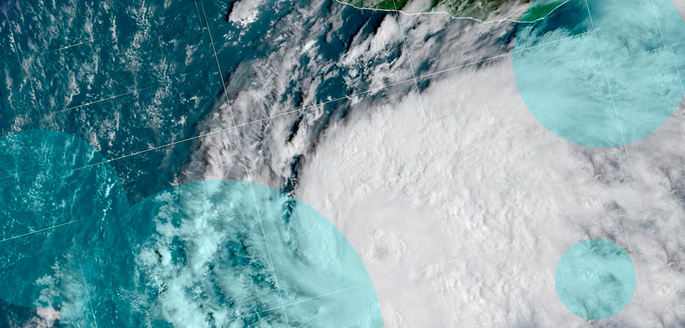
Hurricane Vance strengthened into a Category 1 storm off Mexico’s Pacific coast on Friday, October 23, with forecasters warning that rapid intensification could turn it into a major hurricane before the end of the day. Meanwhile, Typhoon Champi is threatening Taiwan and Japan after reaching one of the highest intensities recorded globally this year.
Vance became the 13th hurricane of the 2026 Pacific season and could become the basin’s 10th storm to reach Category 3 intensity or higher.
- Hurricane Vance became the Pacific Basin’s 13th hurricane of 2026 on October 23 and is forecast to strengthen rapidly into a major Category 3 storm.
- Vance could become the seventh consecutive major hurricane in the eastern Pacific this season, with its projected path bringing it closer to Mexico’s Pacific coast early next week.
- Typhoon Champi reached sustained winds of 185 mph and gusts of 225 mph, matching Super Typhoon Sinlaku as the strongest tropical cyclone recorded worldwide in 2026.
According to the US National Hurricane Center (NHC), Vance had maximum sustained winds of 85 mph (140 km/h) early Friday, when its center was approximately 440 miles (710 kilometers) south-southwest of Acapulco, Mexico.
The hurricane was moving north-northwest at approximately 5 mph (8 km/h), with forecasters expecting that general movement to continue through the weekend.
Forecast models indicated the storm could approach the Puerto Vallarta area by Monday, although uncertainty remained over its eventual track and proximity to the Mexican coastline.
Vance’s outer rainbands were already producing gale-force winds and rough seas in Mexico’s Gulf of Tehuantepec.
Hurricane Vance could become seventh consecutive major Pacific storm
Vance developed south of Mexico on Wednesday, becoming the first eastern Pacific storm assigned a name beginning with V since 2018.
Atmospheric and oceanic conditions across the region have remained favorable for tropical cyclone development, supporting the storm’s rapid organization.
The NHC forecast that Vance could reach Category 3 strength by Friday night, qualifying as a major hurricane on the Saffir-Simpson Hurricane Wind Scale.
If the forecast is realized, Vance would become the seventh consecutive major hurricane in the Pacific this year, following Nolo, Odalys, Polo, Rachel, Simon and Trudy.
The unusually active season has produced a succession of powerful storms near Mexico and Hawaii. El Niño conditions and broader warming trends have been linked to unusual weather patterns across the region, including severe flooding and tornadoes in the southwestern United States and prolonged drought in Central America’s Dry Corridor.
The World Meteorological Organization’s Hurricane Committee excludes the less commonly used initial letters Q, U, X, Y and Z from its standard storm naming lists.
Tehuantepecer winds could influence Hurricane Vance’s development
One atmospheric feature potentially supporting Vance’s organization is a strong Tehuantepecer wind event along Mexico’s southern coast. These events occur when powerful offshore winds push cooler air through the Chivela Pass, a gap in the mountains of southern Mexico, and into the Gulf of Tehuantepec.
As the winds move offshore, they can interact with the surrounding tropical environment and increase rotation in the lower atmosphere.
When this rotation aligns with an existing tropical disturbance over warm ocean waters, it can support the organization of thunderstorms around a developing low-pressure center.
Such conditions can contribute to tropical cyclone development, particularly when other environmental factors favor strengthening.
Forecast models suggest Vance could initially continue northwest before turning somewhat back toward Mexico.
The FOX Forecast Center said it would continue monitoring changes in the hurricane’s intensity and projected movement as the storm approaches the country’s Pacific coast.
Typhoon Champi reaches 185 mph and threatens Taiwan and Japan
In the western Pacific, Typhoon Champi has weakened from its peak intensity but remains a powerful tropical cyclone posing a threat to Taiwan and Japan.
Champi previously underwent rapid intensification, reaching maximum sustained winds of 185 mph with gusts as high as 225 mph.
At that intensity, the storm matched Super Typhoon Sinlaku as the strongest tropical cyclone recorded anywhere in the world during 2026.
Champi subsequently weakened, with sustained winds reported at approximately 120 mph as it approached Taiwan.
The storm developed over exceptionally warm ocean waters in an environment characterized by low vertical wind shear and limited dry air. These conditions allowed its circulation and thunderstorms to organize rapidly, supporting the development of an exceptionally intense tropical cyclone.
Champi also generated extremely large waves. Significant wave heights near the storm’s center reached 68 feet, representing the average height of the highest one-third of waves observed.
The measurement indicates the severity of the marine conditions associated with the typhoon, particularly for vessels operating near its center.
Champi forecast to weaken as it approaches Taiwan and Japan
Forecasts indicate Champi will gradually weaken as it moves closer to Taiwan, although the storm remains capable of producing dangerous conditions across affected areas.
The typhoon is expected to make a close approach to Taiwan before likely curving toward Japan.
Its projected movement places both territories within the broader area of concern, even as the storm loses strength from its earlier super typhoon intensity.
The simultaneous development of Vance in the eastern Pacific and Champi in the western Pacific comes during an unusually active tropical cyclone season.
For Mexico, the immediate concern is Vance’s potential intensification into a major hurricane and its projected approach toward the Pacific coast early next week.
Across the western Pacific, attention remains on Champi’s weakening trend and its movement past Taiwan toward Japan, following a period in which the storm matched the highest tropical cyclone intensity recorded worldwide in 2026.