Follow Beinsure
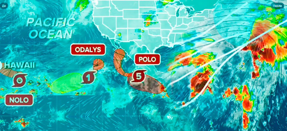
A hurricane watch is in effect for Hawaii’s Big Island as Tropical Storm Nolo strengthens south of the island chain, threatening heavy rainfall, flooding and damaging winds through the weekend.
Nolo had maximum sustained winds of 60 mph early Thursday and was about 285 miles south of South Point on Hawaii Island, according to the Central Pacific Hurricane Center.
The storm is expected to strengthen into a hurricane and has the potential to reach major hurricane intensity as it approaches the state this weekend.
The hurricane watch covers Hawaii County, where hurricane conditions are possible as Nolo moves closer. Flood watches also remain in effect through Saturday afternoon for the Big Island, Maui, Lanai, Molokai and Kahoolawe.
Hawaii emergency officials have urged residents and visitors to prepare for a serious weather event.
Heavy rainfall presents one of the largest threats, with saturated ground increasing the potential for flash flooding, landslides and damage to roads and property.
The Big Island is expected to receive between 15 and 20 inches of rain across broad areas, while isolated locations could approach 35 inches. Maui could receive 5 to 10 inches, with localized totals reaching around 20 inches, depending on Nolo’s track and speed.
Moisture on the northern side of the storm is expected to bring heavier showers to the Big Island before spreading toward Maui. Windward and southeastern sections of Hawaii Island face the greatest rainfall risk, with considerable flooding possible Friday and Saturday.
Nolo’s slow movement adds to the concern. Tropical systems moving gradually near mountainous islands often produce prolonged rainfall over the same areas, increasing runoff into streams and low-lying communities.
National Weather Service forecasts warn that overflowing streams and drainage systems could close roads and damage property. Steep terrain across parts of Hawaii also raises the risk of landslides as rainfall accumulates.
Hurricane-force winds begin at 74 mph, and the forecast allows for those conditions on portions of the Big Island as Nolo approaches. Coastal areas exposed to the south could also experience elevated water levels and damaging surf.
Forecasters expect Nolo to strengthen more quickly as it moves across unusually warm waters south of Hawaii.
Rapid intensification occurs when maximum sustained winds increase by at least 35 mph within 24 hours, leaving communities less preparation time if a storm develops faster than forecast.
Nolo arrives during an active 2026 tropical cyclone season for Hawaii. The state has already faced several nearby systems, adding weather pressure to communities that have dealt with repeated flooding since Kona lows began affecting the islands last winter.
Previous storms have forced evacuations, closed roads and caused power outages across parts of the state. Hurricane Lowell generated warnings for Oahu and Kauai earlier in September, while Lala passed close to the Big Island in August.
The recurring weather events have increased pressure on infrastructure and emergency services before Nolo’s arrival. Additional rainfall from the storm could worsen existing damage in locations where drainage systems, roads and slopes remain vulnerable after earlier storms.
The wider Pacific remains active at the same time. Hurricane Polo continues to affect Mexico’s southwestern coast with heavy rain, strong winds and dangerous marine conditions despite remaining offshore.
Polo reached Category 5 strength earlier this week, with maximum sustained winds reaching 160 mph. By Thursday morning, the hurricane had weakened slightly to around 155 mph as it began moving farther from southwestern Mexico.
A tropical storm warning remains in place for sections of Mexico’s Pacific coast. Heavy rainfall across Guerrero and neighboring states carries a continued risk of flash flooding and landslides even as Polo’s center stays offshore.
The simultaneous storms come during a Pacific season influenced by strengthening El Niño conditions and warm ocean temperatures. Those conditions have supported several powerful tropical systems across the basin during 2026.
For Hawaii, Nolo’s exact path remains uncertain, and a relatively small shift could materially change wind and rainfall totals across individual islands. Flooding remains the more widespread concern because heavy rain is expected even if the center stays offshore.