Overview
- Post-Tropical Storm Rachel made landfall in northern Baja California on October 10, bringing heavy rainfall, strong winds and dangerous coastal flooding to Southern California.
- Long Beach ordered evacuations along its Peninsula after powerful waves damaged waterfront homes and destroyed sections of the boardwalk. Flash flood warnings covered parts of San Diego, Riverside and Imperial counties.
- San Diego County faces continued flooding risks through October 11, with mountain and desert wind gusts forecast at 40–55 mph. The storm arrives during an exceptionally strong El Niño event.
Post-Tropical Storm Rachel made landfall in northern Baja California on Saturday night, October 10, 2026, bringing powerful winds, torrential rainfall and damaging coastal flooding to Southern California.
Authorities issued flash flood warnings across several counties as high surf damaged oceanfront homes in Long Beach and threatened additional coastal communities.
By 11 p.m. Saturday, the storm’s center was approximately 80 miles south-southeast of San Diego, according to the National Hurricane Center. Rachel had already transitioned into a post-tropical cyclone, but forecasters warned that heavy rainfall and hazardous conditions would continue across Baja California and the southwestern United States.
The National Weather Service issued overnight flash flood warnings covering parts of San Diego, Riverside and Imperial counties, including sections of the Coachella Valley and the communities of El Cajon, Santee and Blythe.
At 1:17 a.m. Sunday, weather radar detected intense rainfall over the Coachella Valley, affecting southeastern Palm Springs, Coachella, Palm Desert, Indio and Rancho Mirage. Rainfall rates reached approximately 0.75 to 1 inch per hour in some locations, raising concerns about rapidly developing flash floods.
Coastal communities faced a separate threat as powerful waves and high tides pushed seawater into residential neighborhoods. Long Beach reported flooded streets and homes by Saturday night, with its Peninsula neighborhood suffering significant damage to its waterfront infrastructure.
Long Beach evacuations follow severe coastal flooding
Authorities ordered evacuations for oceanfront residents along the Long Beach Peninsula as repeated waves breached coastal defenses and damaged properties.
Seawater entered homes and surrounding streets, while sections of the boardwalk began to collapse under the force of the surf. The damage affected a neighborhood already vulnerable to high tides and coastal erosion.
City inspectors declared eight buildings unsafe to enter after assessing structural damage, according to local authorities. Long Beach also restricted access to affected areas while crews worked to reinforce shoreline protections.
The storm’s effects extended beyond Long Beach. Newport Beach, Laguna Beach, Huntington Beach and San Diego were preparing for another period of high tides on Sunday morning.
Although Rachel’s center tracked south of the US-Mexico border, its circulation continued generating powerful wave activity along Southern California’s coastline.
The National Weather Service warned that the combination of high surf, elevated tides and onshore winds could produce additional flooding in exposed coastal neighborhoods, particularly those facing south.
Residents in vulnerable locations faced the risk of further erosion, property damage and seawater entering low-lying buildings.
San Diego faces heavy rainfall and flash flood risks
San Diego County remained under a tropical storm watch as Rachel’s remnants moved through the region.
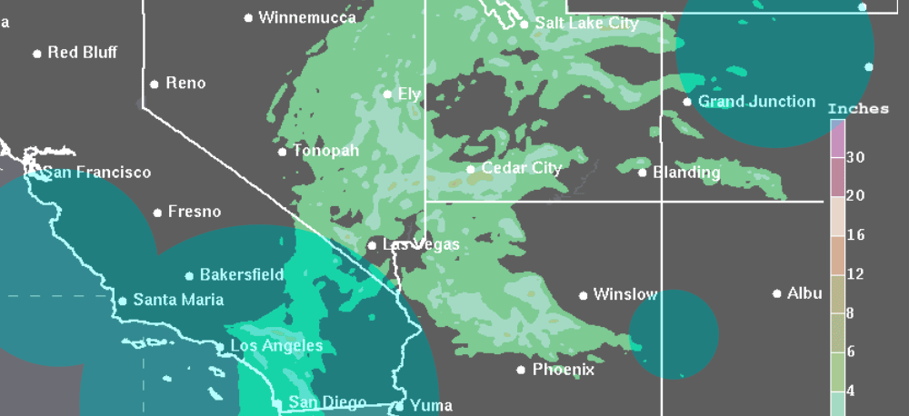
The National Weather Service forecast moderate to heavy rainfall from late Saturday through Sunday afternoon, with the greatest accumulation expected across San Diego County, surrounding mountains and desert areas.
Moderate to heavy rain is expected late Saturday through Sunday afternoon, with the heaviest rain expected over the mountain, deserts, and across San Diego County.
A coastal flood warning remained in effect until 3 p.m. Sunday, while the tropical storm watch extended through Tuesday.
Authorities also issued a flood advisory for the San Diego River near Fashion Valley. The river was forecast to crest slightly above 8 feet before noon Sunday, followed by a gradual decline.
In metropolitan San Diego, forecasters projected peak gusts of approximately 25 mph. Mountain and desert communities faced considerably stronger winds, with gusts expected to reach 40–55 mph.
The weather service warned that strong winds could damage porches, awnings, carports, sheds and mobile homes that were not properly anchored. Large tree branches could also break, creating additional hazards for residents and motorists.
The storm’s forecast track shifted farther south on Saturday, reducing the likelihood of a direct passage through San Diego County. Nevertheless, forecasters continued warning about heavy rainfall, flooding and wind damage.
Los Angeles County was expected to receive lighter precipitation, generally between 0.25 and 1 inch across much of the region. Additional rainfall could arrive Monday as a separate, colder weather system moves through Southern California.
The National Weather Service anticipated scattered light showers, with more populated areas potentially receiving another 0.25 inches of precipitation.
Emergency preparations continue across Southern California
Local authorities activated emergency measures ahead of Rachel’s arrival, with particular attention to flooding, dangerous surf and vulnerable residents.
In San Diego, officials implemented shelter arrangements for unhoused residents and opened recreation centers as distribution points for empty sandbags.
Residents were encouraged to report storm damage, flooding and related hazards through municipal emergency services.
San Diego residents can report non-emergency flooding or damage by calling 619-527-7500 or using the city’s Get It Done application.
The National Weather Service initially issued the tropical storm watch for San Diego County on Friday, when Rachel was approximately 900 miles from the Baja California coast.
As the system accelerated toward northern Baja California, forecasters revised its projected path while maintaining warnings for heavy rain and dangerous coastal conditions.
Rachel’s arrival is unusual in California’s tropical storm history
Rachel’s approach is particularly notable because tropical cyclones rarely retain tropical-storm strength while moving into California.
Only two storms in the modern historical record have passed through the state while maintaining tropical-storm intensity.
The first, known as El Cordonazo, or the Lash of St. Francis, struck Long Beach and San Pedro in September 1939. That storm delivered 5.62 inches of rainfall to Los Angeles over three days and generated wind gusts reaching 65 mph.
Flooding caused 45 deaths on land, while another 48 people died at sea. California experienced another rare encounter with a tropical cyclone in September 1997, when Hurricane Nora moved northward from Baja California.
Nora briefly maintained tropical-storm intensity as its center passed near the California-Arizona border.
Although California avoided the more extensive damage recorded in Baja California, the storm produced street flooding in Imperial County, the Coachella Valley and San Diego.
Large waves generated by Nora and another storm also struck beachfront properties in Seal Beach. Three homes sustained serious damage, while another 45 properties experienced minor damage.
The 1997 storm occurred during a very strong El Niño, a climate pattern associated with increased tropical cyclone activity in the eastern Pacific.
Strong El Niño conditions accompany Rachel in 2026
Rachel is approaching Southern California during another exceptionally strong El Niño episode.
El Niño develops when ocean temperatures rise across the central and eastern equatorial Pacific, influencing atmospheric circulation and weather patterns far beyond the tropical Pacific.
The phenomenon is commonly associated with greater hurricane activity in the eastern Pacific and an increased likelihood of above-average winter precipitation in Southern California.
On October 8, the National Oceanic and Atmospheric Administration’s Climate Prediction Center reported that the current El Niño continued to intensify.
Its October outlook assigned an 83% probability to the event reaching a historically exceptional strength during October through December, potentially exceeding previous El Niño episodes in records dating to 1950.
That probability had risen from 75% in the preceding month’s forecast.
The agency also indicated that strong-to-very strong El Niño conditions were likely to persist into early 2027.
Although El Niño can influence seasonal rainfall and storm activity, it does not determine the precise timing or severity of individual weather events.
For Southern California, the immediate concern remains the combination of rainfall, strong winds and damaging surf associated with Rachel.
Flood warnings across inland communities and coastal flood alerts extending into Sunday afternoon indicate that significant hazards remain even after the storm lost its tropical classification.
With another weather system expected to bring showers on Monday, the region could face additional rainfall before conditions begin to improve.