Hurricane Idalia plowed into Florida’s Gulf Coast with howling winds, torrential rains and pounding surf, then weakened as it turned its fury on southeastern Georgia, where floodwaters trapped some residents in their homes, according to Reuters.
Hours after Idalia slammed ashore as a powerful Category 3 hurricane at Keaton Beach in Florida’s Big Bend region, packing winds of about 125 mph (201 kph), authorities were still trying to assess the full extent of damage in the hardest-hit areas.
As predicted, Idalia crossed Florida’s shoreline in the heart of its largely rural Big Bend region, where the state’s northern Gulf Coast panhandle curves into the western side of the Florida Peninsula.
The area is roughly bounded by the cities of Gainesville and Tallahassee, the state capital.
The same region, featuring a marshy coast and threaded with freshwater springs and rivers, was devastated by a major hurricane in 1896.
The hurricane unleashed destructive winds and torrential downpours that were forecast to cause flooding up to 16 feet (5 m) deep along Florida’s Gulf Coast. Some 12 hours after landfall, the governor said no drowning victims had been found caught in the storm surge.
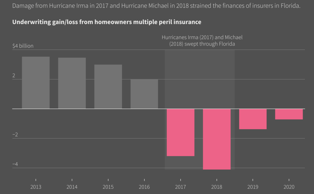
Insured property losses in Florida were projected to run $9.4 bn, investment bank UBS said in a research note based on preliminary estimates.
Insured losses in Florida

Moody’s RMS looks at the projected Idalia forecasts. Given the very warm sea surface temperatures Idalia’s path across the eastern Gulf of Mexico – the warmest for 40 years – there remains significant intensification potential.
While the storm is moving relatively fast (faster than Hurricane Ian last year), with Idalia’s anticipated trajectory, there is currently likely to be less extensive inland flooding damage and losses than from Ian.

The loss from Idalia will be significantly determined by its landfall location, particularly how much damage is caused in the Tampa Bay region. The cone of uncertainty for its landfall area is narrowing down on the along the west coast or Big Bend region of Florida.
Sarah Hartley, Senior Manager, Event Response, Moody’s RMS
The Big Bend has not been struck by a hurricane since Gladys in 1968; it is one of the least-developed and most sparsely populated regions in the state, however, any coastal properties will be very vulnerable to severe storm surge.
As many as 565,000 utility customers had lost electricity at some point during and after the storm.
Florida Transportation Secretary Jared Perdue told the briefing that state National Guard teams were conducting water rescues from vehicles in Hernando and Taylor counties.
Idalia is moving toward the north at 14 miles per hour (22 km/h). A faster motion toward the north and north-northeast is expected through early Wednesday while Idalia approaches the Gulf coast of Florida.
Maximum sustained winds have increased to 85 miles per hour (140 km/h) with higher gusts. Rapid intensification is expected before landfall, and Idalia is forecast to be a major hurricane when it reaches the Gulf coast of Florida Wednesday morning.
According to NOAA, NHC tropical cyclone forecast tracks can be in error. This forecast uncertainty is conveyed by the track forecast “cone”, the solid white and stippled white areas in the graphic. The solid white area depicts the track forecast uncertainty for days 1-3 of the forecast, while the stippled area depicts the uncertainty on days 4-5.
Historical data indicate that the entire 5-day path of the center of the tropical cyclone will remain within the cone about 60-70% of the time.
To form the cone, a set of imaginary circles are placed along the forecast track at the 12, 24, 36, 48, 72, 96, and 120 h positions, where the size of each circle is set so that it encloses 67% of the previous five years official forecast errors. The cone is then formed by smoothly connecting the area swept out by the set of circles.


 by
by 


