Follow Beinsure
Hurricane Polo intensified at an exceptional pace this week, moving from a tropical storm with 50 mph winds to an extremely intense hurricane. A NOAA Hurricane Hunter aircraft measured sustained winds near 180 mph in the eyewall and a central pressure of 892 millibars, among the lowest readings recorded in the eastern Pacific.
For catastrophe bond investors, Polo’s central pressure carries more significance than its headline wind speed because Mexico’s Pacific hurricane protection uses parametric triggers tied to storm measurements and location.
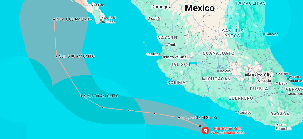
Polo had weakened modestly, with maximum sustained winds of 165 mph and central pressure of 905 mb, according to the US National Hurricane Center. The storm was moving slowly about 200 miles south of Zihuatanejo, with forecasters expecting a west-northwest turn that would take it roughly parallel to Mexico’s coastline over the following days, Insurance Business Magazine stated.
The expected track keeps Polo relatively close to shore, although the NHC said uncertainty remained over its exact distance from the coast. That track matters for residents facing heavy rain and for investors holding Mexico’s Pacific hurricane catastrophe bond.
Mexican President Claudia Sheinbaum said available forecasts did not indicate a direct landfall. She urged residents in Jalisco, Colima and Michoacán to remain alert as conditions developed, while authorities issued a tropical storm warning between Tecpan de Galeana in Guerrero and Punta San Telmo in Michoacán.
“So far, the information we have is that (Polo) will not make a direct landfall on the coast,” Mexico’s President Claudia Sheinbaum said, but she warned residents along the Pacific coast to be vigilant. Sheinbaum highlighted the states of Jalisco, Colima and Michoacan as being at risk.
So far this season, the Pacific has seen 15 storms, all in early September. Polo is the strongest of a batch of three storms currently swirling between Hawaii and the North American mainland.
Data from the Hurricane Hunter aircraft indicated that Polo could still strengthen, because of what NOAA called a “very conducive” environment of extremely warm ocean waters feeding the storm.
Coastal areas of Guerrero and Michoacán are forecast to receive 3 inches to 6 inches of rain, with local totals reaching 8 inches. The rainfall raises flash-flood and mudslide risks across mountainous areas, and schools have closed along sections of the affected coastline.
Mexico has used parametric disaster protection for roughly two decades, combining insurance and capital-market instruments to secure funds after major natural catastrophes. In May 2024, the World Bank issued a $175 mn catastrophe bond covering named hurricanes along Mexico’s Pacific coast for four years, according to data from Artemis.
Under the structure, proceeds from any payout reach the Mexican government through Munich Re and state-owned insurer Agroasemex. Payment depends on predetermined storm measurements rather than documented economic losses.
Central pressure forms an important part of the trigger. The hurricane’s pressure must fall below a specified threshold while its centre remains within defined geographic zones along Mexico’s Pacific coastline.
Market reports have placed the relevant pressure threshold at around 937 mb, Artemis noted. Earlier this week, when Polo was a Category 4 hurricane with central pressure near 955 mb, market commentary indicated the bond faced limited trigger risk under the storm’s projected path.
The situation changed rapidly as Polo strengthened. Its central pressure subsequently fell by more than 60 mb, reaching 892 mb at peak intensity before rising to 905 mb on Wednesday.
Those readings place Polo well below the reported pressure threshold, shifting investor attention toward the geographic component of the trigger. The storm’s location now becomes the main variable determining whether the bond suffers a payout.
If Polo’s centre passes through the specified zones while satisfying the relevant pressure conditions, the transaction faces a potential loss under its parametric structure. If the centre remains sufficiently far offshore or outside the defined areas, investors retain their principal despite Polo’s exceptional intensity.
Mexico has also expanded its broader parametric insurance protection. At its 2026 renewal, the government roughly doubled the size of the programme to about $575 mn, increasing the financial protection available against qualifying natural catastrophes.
Polo was about 335 miles south-southeast of Manzanillo and is slowly moving. US forecasters expect the storm will start turning sharply to the northwest and follow a path that steers it away from Mexico’s coast through the weekend.
Still, Polo’s core is expected to track near the coast and tropical storm warnings have been issued from Tecpan de Galeana to Punta San Telmo, and a watch has been extended westward to Playa Perula.
Polo is a relatively compact hurricane – its strongest winds extend only 35 miles from its center.
Scientists monitoring the ocean temperatures say the current El Niño climate phenomenon is now the strongest on record.
Daily sea surface temperatures in a key region of the central-eastern Pacific were 3.05C above average on 19 September – exceeding the previous record of 3.02C set during the very strong El Niño of 2015.
Some longer-term measures of El Niño have not yet hit record levels but this is likely to change, with the peak not expected until later this year.
Warmer ocean waters mean storms can pick up more energy, leading to higher wind speeds.
El Niño is a naturally-occurring pattern, which happens about every two to seven years and tends to last for around a year.
Trade winds that typically blow from east to west across the Pacific Ocean can weaken or even reverse, allowing warm water to spread eastwards.
Heat is then released from the ocean into the atmosphere which can boost global temperatures and drive changes in weather patterns around the world.