Tropical Storm Isaias formed over the southwestern Gulf and is forecast to intensify quickly as it moves toward the northern Gulf Coast. The National Hurricane Center expects rapid strengthening over the next day or two, raising the prospect of a dangerous hurricane approaching the US coast by the end of the week.
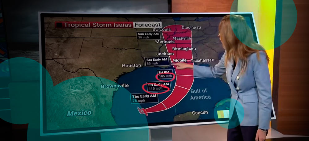
Isaias currently has maximum sustained winds of 40 mph and sits roughly 600 miles south of the mouth of the Mississippi River. The storm is moving east-northeast above Mexico’s Yucatan Peninsula before a forecast turn north toward the Gulf Coast.
Forecast guidance puts Isaias near Category 2 strength by Thursday night or early Friday, with winds around 110 mph. Some weakening is expected before landfall as the storm encounters less favorable atmospheric conditions near the northern Gulf, though forecasts still bring it ashore as a hurricane.
Hurricane and storm surge watches are expected for parts of the northern Gulf Coast. Those alerts are issued when hurricane-force winds of at least 74 mph or life-threatening coastal flooding are possible within 48 hours.
For residents and businesses from southern Louisiana through the Florida Panhandle, the risk extends well beyond wind speed.
Forecasts include flooding rain, storm surge and tornadoes embedded inside outer rainbands as Isaias approaches the coast beginning Friday.
Isaias is also positioned to become the first Atlantic hurricane of 2026. That would end a record-long wait for the season’s first hurricane, a delay associated with a likely record-strength El Niño that has suppressed tropical development across much of the Atlantic this year.
The exact landfall point is still uncertain. Current forecasts place the area of concern from Louisiana through Florida’s Big Bend, with eastern Louisiana and the western Florida Panhandle sitting inside the broader forecast zone.
That uncertainty matters for emergency planning because relatively small changes in track affect where the strongest winds, storm surge and heaviest rain arrive. They also change how long Isaias remains over exceptionally warm Gulf water before reaching the higher wind shear closer to the coast.
Florida started preparing before Isaias received tropical storm status. Gov. Ron DeSantis declared a state of emergency for 25 counties on Tuesday and urged residents to prepare disaster plans and hurricane supply kits.
State emergency teams are positioning generators, fuel, food, water and flood barriers around Tallahassee and Santa Rosa. Those preparations leave response equipment closer to areas expected to face flooding, power disruption or storm damage.
Isaias is developing inside an Atlantic season heavily influenced by El Niño. Those atmospheric conditions have restricted tropical development for much of the season, even as ocean temperatures remained favorable.
The Gulf itself is exceptionally warm for early October. Those waters provide abundant energy for intensification, but warm water alone doesn’t determine hurricane strength.
Wind shear describes changes in wind speed or direction at different levels of the atmosphere. Strong shear disrupts the vertical structure of tropical cyclones and often prevents storms from organizing or maintaining hurricane intensity. That process has limited Atlantic storms throughout much of the 2026 season.
Isaias is currently moving through an area of relatively low wind shear in the southern Gulf. Conditions become less favorable farther north, where stronger shear is expected near the Gulf Coast.
That gives forecasters two competing signals. Warm Gulf water supports rapid strengthening, while higher shear closer to land increases the odds of weakening before landfall.
Isaias is forecast to move relatively quickly toward the northern Gulf Coast. A faster storm spends less time exposed to hostile wind shear, leaving less opportunity for its circulation to break down before reaching land.
A slower track would expose the system to those conditions for longer and increase the chance of more substantial weakening. The timing of the northward turn therefore feeds directly into the intensity forecast.
Track and intensity are also connected through the storm’s vertical structure.
A stronger hurricane extends farther upward through the atmosphere. Winds at those higher levels influence its movement differently than they influence a weaker and shallower tropical system.
Changes in intensity therefore affect steering, and changes in steering affect intensity. A shift in track changes how long Isaias remains over warm water and how much time it spends inside stronger shear.
Storm surge presents a separate threat near and east of the landfall area, where onshore winds push Gulf water toward the coast. The precise surge exposure depends heavily on the final track and intensity close to landfall.
Tornadoes are another concern as outer rainbands move inland. Tropical cyclones often produce short-lived tornadoes away from the center, extending severe-weather risk outside the area experiencing the strongest hurricane winds.
For insurers, energy companies, logistics operators and coastal businesses, the next phase of the forecast will matter more than the current storm category.
A relatively modest shift in Isaias’ path changes which ports, offshore facilities and populated coastal areas receive the strongest conditions.
We see the main risk as the combination of rapid intensification and limited preparation time. Isaias formed only a few days before its expected Gulf Coast landfall, leaving governments, businesses and residents with a compressed window to respond.
The storm still has several atmospheric variables working in opposite directions. Record-warm Gulf water supports strengthening, while higher wind shear nearer the coast works against it.
By Friday, the balance between those factors should become clearer. Until then, the northern Gulf Coast faces a forecast in which track, intensity and timing remain closely connected, with flooding rain and coastal impacts already among the more consistent threats.