Overview
Florida has placed 25 counties under a state of emergency as the Gulf storm now named Tropical Storm Isaias strengthens and heads toward the northern Gulf Coast.
Gov. Ron DeSantis signed Executive Order 26-202 on October 6, when the system was still Tropical Depression Nine. The order gives the Florida Division of Emergency Management more room to stage supplies and position response teams before conditions deteriorate.
State Emergency Response Team crews are positioning supplies in Tallahassee and the Santa Rosa area, with resources ready for deployment across North Florida. The inventory includes generators, fuel, flood barriers, bottled water, shelf-stable meals, flood buckets, tarps, Tiger Dams and sandbags.
DeSantis also urged residents to review disaster plans and restock hurricane supplies. The state order was issued before the National Hurricane Center upgraded the depression to Tropical Storm Isaias early Wednesday.
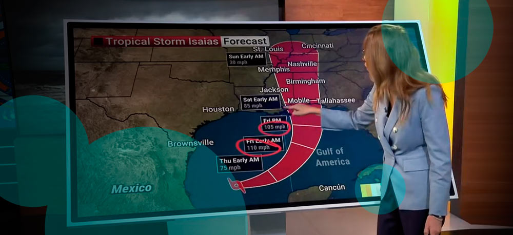
That upgrade arrived at 4 a.m. CDT on October 7. Isaias had maximum sustained winds of 40 mph and was moving east-northeast at 8 mph, roughly 580 miles southwest of the mouth of the Mississippi River. The NHC said rapid strengthening was forecast over the following couple of days.
Rain, wind and coastal flooding extend well beyond the center of a tropical system. North Florida also faces the prospect of isolated tornadoes inside outer rainbands, while additional rainfall adds pressure to areas where soils are already saturated.
The Panhandle therefore sits inside a wider operational risk zone even before forecasters settle on an exact track.
Florida stages equipment before landfall forecast firms up
The state’s response follows a familiar hurricane strategy: move equipment before roads, ports and local infrastructure become harder to access.
Generators and fuel matter if electricity networks fail. Flood barriers, Tiger Dams and sandbags give local crews options around roads, public facilities and low-lying areas. Water and shelf-stable food support communities where normal distribution is disrupted.
The National Hurricane Center had already advised interests across the US northern Gulf Coast to monitor the system when it was Tropical Depression Nine. The storm had strengthened into Isaias, confirming the faster development forecasters had been watching.
Putting those supplies in Tallahassee and Santa Rosa also places them closer to the Panhandle, one of the areas under scrutiny as Isaias moves across the Gulf.
We think the timing is more relevant than the size of the initial deployment. Tropical systems often change speed, direction or intensity faster than emergency logistics networks reposition heavy equipment. Florida is effectively buying response time.
Forecast risk extends beyond the coast
Current NHC guidance has Isaias moving across the Gulf before turning toward the northern coast. Forecast models also support further strengthening as the storm crosses warm water.
Heavy rainfall raises the threat of flash flooding, especially where recent storms have already increased soil moisture. Strong winds create power and property-loss exposure. Coastal flooding threatens low-lying communities, roads and businesses near the shoreline.
Tornado risk adds another layer because tropical rainbands often spread well away from the storm center.
For insurers, utilities and emergency managers, this makes the forecast cone only part of the planning problem. Damage doesn’t stop at the line marking the projected center.
A track farther west changes where the strongest winds and surge arrive. A turn farther east shifts more exposure toward the Florida Panhandle and Big Bend. Rainfall coverage remains broader than either scenario.
Why Florida moved before Isaias became a hurricane threat
Waiting for a hurricane designation would leave less preparation time if strengthening accelerates.
Isaias already moved from a tropical depression to a named storm overnight. The NHC’s Wednesday advisory explicitly called for rapid strengthening over the next couple of days.
That doesn’t make every county under the emergency order equally exposed. It does mean state agencies have a wider legal and operational framework ready before local needs become clearer.
Storm intensity affects wind losses and surge. Track determines which communities receive the worst conditions. Forward speed influences rainfall totals and how long emergency services deal with sustained disruption.