A strengthening El Niño looks set to mute the next Atlantic hurricane season, federal forecasters and outside meteorologists said. The shift won’t erase lethal storm risk. One landfall still changes the year, accordibng to Insurance Journal report.
The National Oceanic and Atmospheric Administration issued its Atlantic seasonal outlook on Thursday, assigning a 55% chance of below-average activity.
NOAA expects eight to 14 named storms, with three to six reaching hurricane strength and one to three becoming major hurricanes.
A normal Atlantic season produces 14 named storms. Seven usually become hurricanes. Three reach major hurricane status, with winds above 110 mph, or 177 kph.
Private and academic forecasting teams broadly reached the same view. Eighteen groups have issued seasonal forecasts, and most expect a below-average summer and autumn. Their average call sits at about 12 named storms, with five hurricanes and two major hurricanes. They also expect Accumulated Cyclone Energy, an index tracking storm strength and duration, to reach 80% of normal.
Colorado State University, which began seasonal hurricane forecasting in 1984, expects the weakest overall Atlantic activity since 2015. That year brought the strongest El Niño of the past 75 years.
Colorado State hurricane specialist Phil Klotzbach said the university’s June update likely cuts the forecast further.
The outlook follows a long active run. Nine of the past 10 Atlantic hurricane seasons finished above normal or hyperactive. Last year opened slowly, then surged, producing a near-record three Category 5 hurricanes.
Insurers still face a large exposure base. Munich Re data show inflation-adjusted global damage from tropical cyclones rose from an average of $11.4 bn a year in the 1980s to $109.7 bn a year over the past decade. The Atlantic, Gulf of Mexico, and Caribbean account for three-quarters of those losses.
Hurricanes, typhoons, and cyclones describe the same weather event. Regional naming differs.
We should expect a less active year than certainly what we’ve seen recently, and perhaps significantly so below average. But again, it only takes one to cause real devastation and destruction in the mainland U.S. or even in Hawaii.
Kristen Corbosiero, an atmospheric scientist at the University at Albany
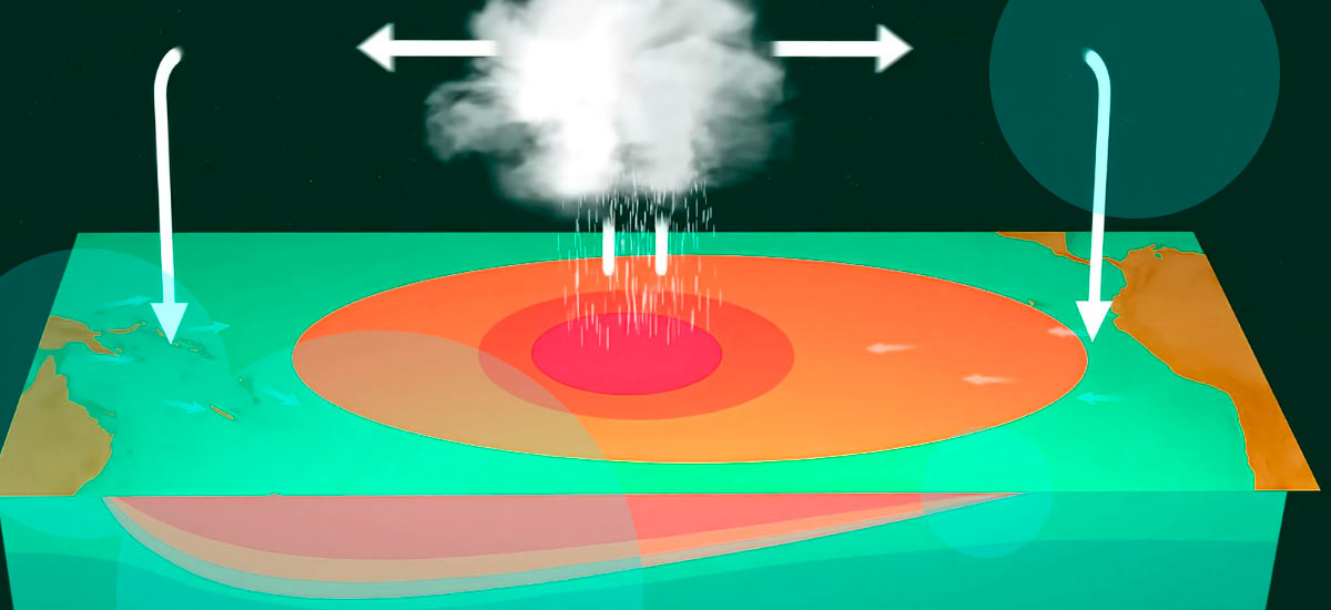
El Niño refers to cyclical warming across parts of the central Pacific. It distorts global weather patterns, especially in winter. Scientists have linked El Niño for decades with below-average Atlantic hurricane activity, along with more intense and more frequent storms in the central and eastern Pacific.
This year, many forecasters expect a strong, superstrong, or record-level El Niño. La Niña, its cooler opposite, usually leaves the Atlantic more active and more prone to stronger storms.
NOAA Administrator Neil Jacobs said Thursday there’s a 98% chance of El Niño conditions this summer and an 80% chance of moderate or strong El Niño.
Analysis of storm and El Niño data found Atlantic seasons with strong or very strong El Niño conditions produced about two-thirds as many named storms and half as many hurricanes as the 1991-2020 average.
El Niño suppresses Atlantic storm formation through several channels. The most important one involves crosswinds roughly 1 mile to 7 miles above the surface, or 1.5 to 11 kilometers.
Those winds “can basically blow apart the thunderstorms that make up” a hurricane, Corbosiero said.
“A stronger than normal wind shear tends to tilt storms as they try to develop,” said Brian Tang, an atmospheric scientist at the University at Albany. “It pushes dry air into storms. And prevents storms from developing in the first place. And if they do develop, it also prevents them from intensifying.”
El Niño reduces weaker storm counts and intensity. Once a storm reaches hurricane strength, with 74 mph winds, the pattern changes. Matthew Rosencrans, lead hurricane season forecaster with NOAA’s National Weather Service, said hurricanes then become “kind of like a self-feeding entity” and face less pressure from El Niño wind shear.
Peak-season forecasts point to strong westward wind shear in the main development region. That zone produces the largest and longest-lived hurricanes, which often roll off Africa and strengthen while moving west over the Atlantic.
El Niño years usually produce fewer of those systems.
Klotzbach’s analysis of the 15 strongest El Niño years since 1950 found 37 named storms, 11 hurricanes, and three major hurricanes made landfall in the continental United States. During the 15 coldest La Niña years, 61 named storms, 31 hurricanes, and 10 major hurricanes struck America’s Gulf and Atlantic coasts. He said El Niño reduces Atlantic Coast landfall frequency more than Gulf Coast landfall frequency.
El Niño and La Niña affect the central and eastern Pacific in the opposite way they affect the Atlantic. Forecasters therefore expect a busier season across those Pacific regions. Jacobs said the eastern Pacific has a 70% chance of an above-normal season.
NOAA forecasts 15 to 22 named storms in the Pacific. Nine to 14 should become hurricanes, and five to nine should reach major hurricane strength. A normal season brings 15 named storms, eight hurricanes, and four major hurricanes.
Rosencrans said the main central Pacific development zone shifts closer to Hawaii during El Niño years.
Eastern Pacific storms near Baja Mexico often “go west, affect the fishies and little else,” Corbosiero said. At times, though, they turn east or north and produce severe damage. Hurricane Otis smashed into Mexico in 2023. Hurricane Lester brought heavy rain to the U.S. Southwest in 1992.
Hawaii remains exposed despite its small footprint in a large ocean. In 1992, an El Niño year with few Atlantic storms, Hurricane Iniki struck Hawaii. The same season, Hurricane Andrew devastated Miami.